English| EUR
Suggested for you
More currencies
Choose a language
The Corinth Canal slices through 6.4 kilometers of limestone to join two gulfs and bypass a 400-kilometer detour around the Peloponnese. Opened in 1893, the canal creates a navigable shortcut between western and eastern Greek waters. Understanding the connection explains why ships still pass through despite the narrow width and restricted draft.
Quick answer
The Corinth Canal connects the Gulf of Corinth in the west to the Saronic Gulf in the east, effectively linking the Ionian Sea with the Aegean Sea. The man-made waterway cuts through the Isthmus of Corinth at sea level, eliminating the need for vessels to sail around the entire Peloponnesian peninsula. The canal measures 6.4 kilometers long, 24.6 meters wide at water level, and allows passage for ships with a draft of up to 8 meters.
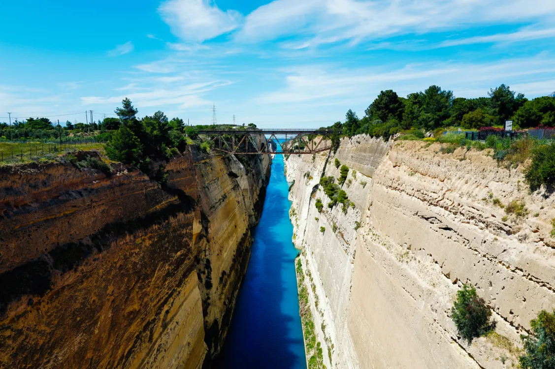
The canal sits at the narrowest point of the Isthmus of Corinth, where just six kilometers of rock once formed the only land bridge between mainland Greece and the Peloponnese. Before 1893, ships traveling between the Ionian and Aegean seas faced a 400-kilometer voyage around the southern cape of the peninsula, adding days to the journey and exposing vessels to some of the Mediterranean's most unpredictable waters. What does the Corinth Canal connect in practical terms? It joins the Gulf of Corinth—an inlet of the Ionian Sea stretching westward between the mainland and the Peloponnese—with the Saronic Gulf, the body of water that opens eastward into the Aegean and serves Athens and Piraeus. The isthmus connection made strategic sense for millennia. Ancient Greeks dragged smaller vessels across the diolkos, a paved trackway, as early as the sixth century BCE. Roman emperors considered cutting through but abandoned the effort. The modern canal, completed by a French company after eleven years of excavation, drops straight through Corinthian limestone at sea level with no locks. The walls rise nearly 80 meters on either side, exposing stratified rock that shifts from pale gray to ochre depending on the light. The width at the waterline—24.6 meters—restricts passage to smaller commercial vessels, private yachts, and tour boats, but the route remains active for freight and leisure traffic that benefits from the shortcut. Viewing access centers on the two road bridges spanning the canal at the northern and southern ends. The submersible bridge at the Posidonia end and the older fixed bridge near Isthmia both offer pedestrian walkways where the drop to the waterway below frames the engineering feat. Ship transits occur throughout the day, though the narrow channel allows only one-way traffic and vessels must schedule their passage in advance. The canal's role as a maritime link between two gulfs remains its defining characteristic, but the site has become equally significant as a vantage point where the scale of the cut—and the ambition required to carve it—registers visually in a way that maps and specifications cannot convey.
“The canal drops straight through Corinthian limestone at sea level with no locks, exposing stratified rock that shifts from pale gray to ochre depending on the light.”
The question of what does the corinth canal connect traces back to antiquity, when Greek rulers first contemplated cutting through the narrow isthmus separating the Aegean Sea from the Ionian Sea. In 67 CE, Emperor Nero initiated the first serious excavation, deploying six thousand Jewish prisoners to dig with pickaxes and shovels. Ancient sources record that Nero himself broke ground with a golden pickaxe. The project collapsed after Nero's death in 68 CE, leaving only rudimentary trenches visible for centuries. For nearly two millennia, ships continued the arduous portage across the Isthmus of Corinth on the diolkos—a paved trackway where vessels were hauled overland on wheeled platforms. The strategic waterway linking two major gulfs remained unrealized until the Greek government authorized construction in 1881. French engineers initially led the effort, but financial collapse in 1889 forced the Greek contractor Andreas Syngros to assume control. Workers carved through limestone cliffs, reaching depths of 63 meters in some sections, and the canal finally opened to maritime traffic on July 25, 1893. The engineering achievement transformed the sea route between the Adriatic and Athens, eliminating a 185-nautical-mile detour around the Peloponnese peninsula. During World War II, German forces blocked the canal with demolitions in 1944, suspending traffic for years. Modern visitors standing on the pedestrian bridge at Isthmia still observe the original limestone walls—sheer vertical faces that reveal both Roman-era chisel marks from Nero's aborted attempt and the dynamite-scored surfaces left by 19th-century crews. The diolkos trackway remains partially exposed on the western approach, a tangible record of the centuries separating ambition from completion.
Emperor Nero begins excavation with 6,000 laborers, using golden pickaxe for the ceremonial first cut.
Project abandoned after Nero's death; only shallow trenches remain for nearly 1,800 years.
Greek Parliament authorizes canal construction; French company Société Internationale du Canal Maritime de Corinthe takes initial contract.
Canal opens to ship traffic on July 25 after Greek engineers complete the 6.4-kilometer cut through limestone.
German forces detonate explosives, blocking the canal; repairs extend into the post-war period.
Submersible bridges installed at both ends to accommodate modern road traffic and vessel passage.
The Corinth Canal is located at Isthmia Korinthias, 20100, Greece. The most direct approach from Athens is via the A8 motorway by car or using the KTEL intercity bus network.
A8 motorway (Attiki Odos) towards Corinth, exit at Isthmia
KTEL bus from Kifisos Station (Athens) to Isthmia junction
Direct transfer from Athens city center or Athens International Airport
To view the canal, travel to the bridge at Isthmia Korinthias. Arriving within the 06:00–19:00 window ensures optimal natural light for visibility of the canal walls.
The Corinth Canal remains accessible throughout the week to accommodate visitor observation. Please note that hours vary specifically on Tuesdays.
The best time to observe the canal is during the arrival window of 06:00–19:00, which provides optimal natural light to inspect the vertical walls and the water connection. This timeframe ensures clear visibility of the narrow passage between the Gulf of Corinth and the Saronic Gulf.
—
Early hours offer calm water and consistent lighting for observing the canal structure.
Mild 18°C–24°C; pleasant breezes
Clear skies facilitate better depth perception of the canal walls and geography.
Warm 20°C–25°C; stable conditions
Gentle light helps clarify the depth of the water and the engineering of the channel.
Verdict: For optimal visibility of the canal walls and water connection, visit during the 06:00–19:00 window, specifically in the mild months of April or October.
Everything you need to know about what does the corinth canal connect
The Corinth Canal connects the Saronic Gulf in the Aegean Sea with the Gulf of Corinth in the Ionian Sea. This narrow waterway effectively separates the Peloponnese peninsula from the Greek mainland.
The canal is a man-made maritime passage completed in 1893 to shorten the route for vessels. It cut through the Isthmus of Corinth to create a shortcut between two major bodies of water.
For shipping traffic, what does the corinth canal connect to improve transit efficiency? It provides a critical path that saves smaller vessels from circumnavigating the Peloponnese, a journey of several hundred kilometers.
Yes, visitors often access the bridge to observe the limestone walls and the water below. It provides a unique perspective of this engineering marvel that splits the land.
The site is accessible during various times throughout the week, as detailed in the opening hours section. You should refer to the official schedule before planning your transit to the bridge.
In regional terms, what does the corinth canal connect to influence local logistics? It serves as a physical boundary between Central Greece and the Peloponnese, with the Isthmia region acting as a focal point.
There is no charge for visitors viewing the structure from the bridge. The entrance fee is 0 EUR, allowing for free public access to the observation points.
The waterway serves as a primary feature for boat tours and historical sightseeing. By viewing the canal, tourists appreciate how this narrow path shapes the surrounding Peloponnesian landmarks.